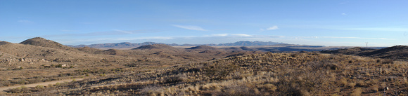
This is a panorama assembled from 6 images. Taken from just off the I-17 freeway, several miles south of Cordes Junction. The deep valley in the middleground is the Agua Fria River. The broad plain beyond that is the Perry Mesa. The higher mountains on the right are the New River Range. Much more info can be found on the Agua Fria National Monument site -
http://www.blm.gov/az/st/en/prog/blm_special_areas/natmon/afria.htmlTo see the image full size hover the mouse over the image and click on the
Download Original in the menu that pops out.